CLICK HERE: to send BEN a little love on the road.
Check out the all NEW Sacklunch.com
Reading List Featuring Books We've been reading lately.
The Big Sack of Sacks, a.k.a.
The Sacklunch Year 1 Archives.

See the ugly logo above? Sign up for AOL and we get $15. Come on, support
the cause. Do it now.
|
These
are the Chronicles of Famous Surf Writer Ben Marcus and his trip
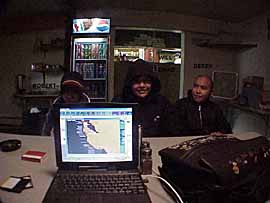
into the Wilds of the Alaskan Frontier. 20:39 YUKON TIME THE RESTAURANT OF THE WELCOME INN, ROSS RIVER, YUKON, CANADA AC/DC's Highway to Hell is playing on the radio right now, sort of an apt theme for today. I'm in the restaurant of the Welcome Inn, using a phone plug on the wall, because this hotel in the middle of nowhere doesn't have phones in the rooms. There's a bunch of local Indian kids hanging around, asking me questions in English and talking to themselves in Casca, their native lingo. They're pretty impressed with all the computer gear, and other people are coming over, wondering if I work for the CBC. Now the kids are pestering me, because they want to watch a DVD. I just went out to the van and got my DVD collection. They're looking through them so I can maybe send this thing.
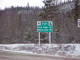
Highway to Hell? Today was a little bit of hell and a lot of heaven. This was the highway to hell if hell had frozen over a bit. It was heaven because it was snowy and scenic and silent. All together, more heaven than hell, but it could have gone the other way. I was just an irresponsible driver today, although things turned out alright. This morning as I was leaving the Carmacks Motel I had two options: Continue on Highway Two, the Klondike Highway, to White Horse, which was the way I had come in. The second option was to take Highway Four, the Campbell Highway, up and around through the back country and down to Watson Lake. Looking on a map the Campbell Highway looked like a long haul, over 300 miles of driving, with only two cities marked: Faro and Ross River. I had read a sign on the way up here which talked about how rural and remote the road was, and it intrigued me. Now I had the option of driving it, but I had no idea how remote or treacherous it might be. Walking out of the Carmacks Hotel, I was semi-accosted by a couple of drunk Indians, a man and a woman. The man asked me for a cigarette. The woman was charming: "Fuck you, White Man. What are you doing here? Go home." I asked about road conditions at a gas station in Carmacks and got a general thumbs down. "You're between seasons so things are really slippery right now," a trucker said. "And if you don't trust your tires, I wouldn't go for it." "You should fill a Jerry Can full of gas," another guy said, and for the next several hours I would wonder if that meant there wasn't any gas on Highway Four. Not only did I not fill up my gas can-which was about three-fourths full-I spent my last $20 in cash to get some gas, but filled the tank only about seven-eighths full. I've completely overloaded my credit card, and when all those charges come in, it's going to bust. I felt irresponsible charging gas, so I used all the cash I had. A bone-headed move that could have been real trouble. Then, unprepared like that, I turned left, not right, and headed for the Campbell Highway. The sign at the start of the road said "Watson Lake 573" which I interpreted as just over 300 miles. I had no idea what the road condition was like, but I figured I would drive until it got dangerous, then turn back, if I had to.
I guess I just opted to go for the nerve-wracking, uncertain and possibly dangerous route, instead of the safer, already-trodden monotonous route. Stupid, maybe, this time of year, but I also had a feeling I was in for some pretty spectacular back-country scenery. I got that right off the bat. The Campbell Highway ran along the Teslin River, another Yukon tributary as good as all the others: Wide, flat, flowing and silent. I stopped a few places along the way, and dreamed about taking a good boat down the Yukon, something that would have the juice to poke around in all the tributaries, and get access to all those lovely creeks and sandbars I saw from the Campbell Highway.
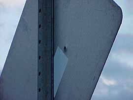
And then I drove and I drove and I drove, on a highway that was no more or less slippery than what I had come down yesterday, but was quieter. I saw maybe five cars in the first hour or two, and almost no people. Every highway sign is a possible victim now, by the way. I think it's the monotony of driving for hours and hours, plus the novelty of being in a place where no one can hear you for miles, that inspires my new fetish for blasting highway signs. In a way, firing off a gun in the middle of nowhere is a kind of celebration: No people! No laws! Yeeha!
And I'd also like to hit one of those things, one of these days. That highway sign fetish gave me a little adrenaline rush along the way. While driving along in the first hour after turning off, I saw a juicy sign on the other side of the road, which looked like a pretty good target. I didn't stop or get out or act on the impulse, I just saw a sign that I felt like plugging, thinking there was no one around. That funky handgun license test I took to buy Mr. Walther stressed how important it is to know what is beyond your target before firing a weapon. Up here you can be pretty certain there is nothing around. All you have to do is listen. Turns out there was a guy parked by the side of the road in his pickup truck, just beyond this sign. That was the only guy parked beside the road in 150 miles of driving. If I had stopped and taken a shot, there might have been hell to pay. It just made me more cautious. As I drove on and on I kept an eye on my gas gauge and began to wonder if I was doing something really stupid. I knew there were two towns coming up, but I had no way of knowing if they'd be open or if there was any gas available. It's hard to stress how remote this all was. A remote route to nowhere in mid-October. I figured I'd go as far as Ross River. If there were no gas available there, I'd have to turn around and go 100 miles back to the Klondike Highway. Adventurous maybe, but also stupid. And scenic. The Campbell Highway was all I expected: wide open, empty and wild. There were a few houses here and there and a car every half an hour or so, but 99% of what I was seeing was raw, unblemished nature. You have to see it to appreciate it, I guess.
I was appreciating it on one level, and stressing on another. What was I doing? Where was I going? Did I have enough gas? Stupid. Scenic, but stupid. I put on The Jam, which made me a feel a little better, and every once in a while I would stop, get out, soak up the sound of silence and maybe break it every once in a while. About three hours into the trip I saw a truck parked along the side of the road, and pulled up behind to make sure everything was okay. The guy was just checking his tires, and I asked him if there were any gas up the road. "Oh sure," he said. "There's gas at Faro, and I think they're still open. It's about 15 minutes up the road. That made me feel better. Much better. I was running out of time and out of gas, but at least you can buy gas. About 15 minutes later, I followed that truck onto a turnout to Faro, which turned out to be a semi-substantial little town, built around what was once the largest open-pit nickel and zinc mine in Canada.
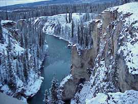
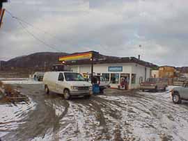
To the bemusement of the gas station guy and a Royal Canadian Mounted Policeman, I very nervously topped off the van and my gas can. The nickel and zinc mine had closed a few years before, but Faro seemed to be doing okay, for a town in the middle of fricking nowhere. There was a funky little Chinese Restaurant which had a giant lake trout on the wall. I bought a BLT, watched an Eddie Murphy movie, then hit the road with a clear conscience. It began snowing and it was now around 5:00 in the afternoon. All of this driving today was done at around 30 or 40 MPH. Occasionally someone would go blasting by me at 70 MPH, and I wondered how they did that on such icy roads. I took it low and slow, particularly on the downhills. If I had needed to jam on the brakes for any reason, the van would have probably flipped over. There was a nice bridge over a tall river canyon at Lapie Creek. I got out and took a photo. A few miles late there was a turnoff to Ross River. It was getting late, so I thought I'd see if there were somewhere to stay. Don't know why Ross River exists, although there was a sign at the entrance giving a little history. It was an Indian trading post that became a Gold Rush trading post and now it's a little town. And now I'm in the restaurant, with a bunch of local kids breathing down my neck. They picked the DVD they want to watch: From Dusk Til Dawn. Some of the local rogues came in asking a bunch of questions. I took their photo and showed them swell.com, and then I let them watch a DVD. They chose From Dusk Til Dawn. I thought I might get busted by the truant officer or something, but it seemed to be okay. Not exactly appropriate material for a bunch of kids, but the cook says it's okay. There's no phones in the rooms so no gin tonight. I'm gonna get to sleep at a reasonable hour, then drive the rest of the way to Watson Lake. There is absolutely nothing between Ross River and Watson Lake, and it's another 200 miles or so. Going to be interesting. At least my gas tanks are full. Now all I have to worry about are moose, flat tires and skidding off the road. These kids are going to scalp me if I don't give up the computer. Bye bye. |

PREVIOUS
ENTRIES
October
22, 2000
October 21, 2000
October 19, 2000
October 17, 2000
October 16, 2000
October 16, 2000
October 14, 2000
October 12, 2000
October 11, 2000
October 10, 2000
October 10, 2000
October
9, 2000
October 8, 2000
October 7, 2000
October 6, 2000
October 6, 2000
October 5, 2000
October 4, 2000
October 3, 2000
October 2, 2000
October 1, 2000
September 30, 2000
September 29, 2000
September 28, 2000
September 27, 2000
September 25, 2000
September 24, 2000
September 23, 2000
September
22, 2000
September 21, 2000
September 21, 2000
September 20, 2000
September 19, 2000
September 19, 2000
September 18, 2000
September 17, 2000
September 16, 2000
September 15, 2000
September 15, 2000
September 14, 2000
September 13, 2000
September 12, 2000
September 10, 2000
September 10, 2000
September 8, 2000
September
8, 2000
PHOTOS
October 1, 2000
October 1, 2000
September 27, 2000